top of page

Alex's Cartography Portfolio
Reference Maps

This is a reference map of Oregon shown at multiple scales, displaying the Willamette Valley, downtown Portland, and surrounding suburban areas by population. It includes roads and water bodies for navigation and general reference.
Housing Vacancy
Census Data

This is a equal- interval, graduated-color choropleth map displaying housing vacancy rates in the U.S. by county and census track levels, with a focus on the Portland Metropolitan area

This is a thematic map showing population, education, age and birthplace census data within Oregon by county. The data is mapped using techniques such as dot density, proportional symbols, bar charts and graduated symbols
Triangle Lake
Mountain Terrain
Lane Community College

This map shows generalized fishing depth recommendations for Largemouth Bass and Kokanee at Triangle lake in Oregon. It displays lake depths and includes reference information such as the local grocery store and the public boat launch.
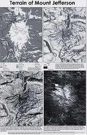
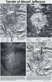
These maps show terrain designs of Mt. Jefferson, displaying multiple layers and contour lines to illustrate which parts of the mountain are the steepest. It also includes reference data such as glaciers, lakes, creeks, rivers and trails tailored for someone hiking on the mountain.

This map shows parking within 250 feet of athletics. It displays amenities and restaurants on and off campus and focuses on wheelchair accessibility including ADA-accessible paths and handicap parking.
bottom of page